Winter storm warning gives way to blizzard warning
The National Weather Service has issued a blizzard warning through 6 a.m. Wednesday. Johnson, Wyandotte, Douglas and Leavenworth counties are included in the warning area.
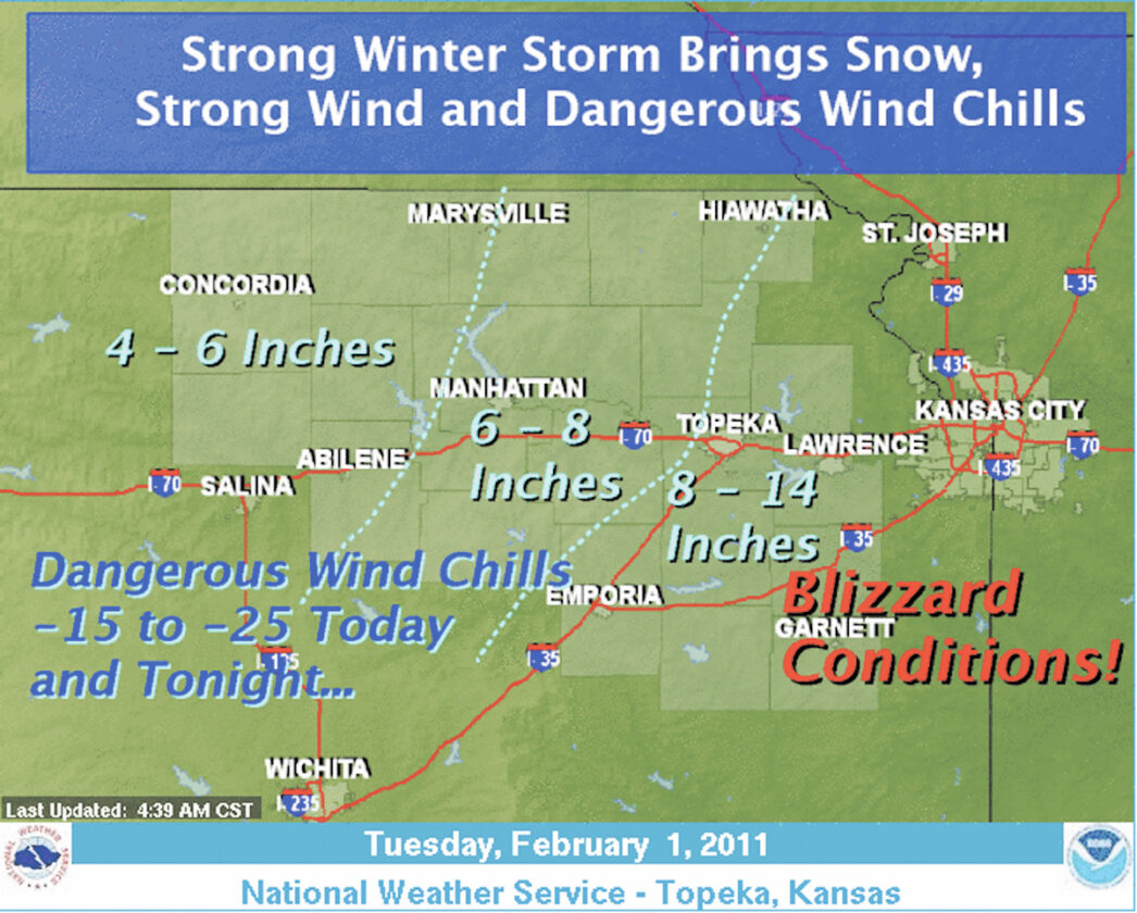
The National Weather Service has issued a blizzard warning for Kansas City area, saying the expected snowstorm could cripple the region.
Classes called off
The prospect of blizzardlike conditions is causing cancellation of schools across the area. Here’s the list as of 6:30 a.m. Tuesday:
• Baldwin City USD 248 has canceled classes Tuesday.
• Basehor-Linwood USD 458 has canceled classes Tuesday.
• Bonner Springs USD 204 has canceled classes Tuesday.
• De Soto USD 232 has canceled classes Tuesday.
• Eudora USD 491 has canceled classes Tuesday.
• Johnson County Community College has canceled classes Tuesday.
• Johnson County/Wyandotte County Catholic schools have canceled classes Tuesday.
• Kansas City Kansas Community College has canceled classes Tuesday.
• Kansas City, Kan., USD 500 has canceled classes Tuesday.
• Lansing USD 459 has canceled classes Tuesday.
• Lawrence USD 497 has canceled classes Tuesday.
• Leavenworth USD 453 has canceled classes Tuesday.
• McLouth USD 342 has canceled classes Tuesday.
• Shawnee Mission USD 512 has canceled classes Tuesday.
• Tonganoxie USD 464 has canceled classes Tuesday.
• University of Kansas Edwardsville Campus has canceled classes Tuesday.
• University of Kansas Medical Center Campus is closed today.
• University of Kansas main campus in Lawrence is closed today.
• University of St. Mary has canceled classes Tuesday.
• West Franklin USD 287 (Pomona) has canceled classes Tuesday.
The warning was issued shortly after 2 p.m. Monday for the Kansas City metro area, which includes Johnson, Wyandotte and Leavenworth counties. Forecasters extended the warning at 3 p.m. to include Douglas County. The blizzard warning remains in effect until 6 a.m. Wednesday.
The NWS said the powerful and potentially life-threatening storm would impact bring a variety of winter weather.
Forecasters says snow will continue to develop and increase in intensity Tuesday across the area. The heaviest snow is expected to develop in the afternoon hours with the highest accumulations southeast of the Kansas Turnpike. Winds will combine with the heavy snow, prompting the blizzard warning. Strong north winds will also bring dangerous wind chills, and cause considerable blowing and drifting of snow.
Snow accumulations of 9 to 14 inches are expected throughout the areas affected by the blizzard watch.
In addition to the snowfall north winds are expected increase to between 25 and 35 mph, which will lead to considerable blowing and drifting.
Conditions are expected to continue to deteriorate with bitterly cold arctic air spreading over the area, with wind chill indices of minus 15 to minus 25 predicted overnight Tuesday.
Forecasters warn conditions may lead to widespread power outages with additional potential storm impacts as temperatures plummet.
Commuters are reminded to make sure your gasoline tank is full before your trip. Also check antifreeze levels in your radiator. Consider taking a winter storm kit along with you, including such items as tire chains, booster cables, flashlight, shovel, a bag of sand or cat litter, blankets and extra clothing, water, a first aid kit or anything else that would help you survive in case you become stranded.
Anyone venturing outsided is reminded that exposed skin can suffer from frostbite in a very short time so dress adequately. Be sure to wear layered clothing a hat and gloves to protect yourself from the dangers of frostbite.
-

- The National Weather Service has issued a blizzard warning through 6 a.m. Wednesday. Johnson, Wyandotte, Douglas and Leavenworth counties are included in the warning area.
Local

Library Corner: Gold Rush program Wednesday; Family ‘Olympics’ this weekend; Dinosaur terraniums

Lawrence High welcomes Team Algeria for World Cup
